REVIEW · SAN FRANCISCO
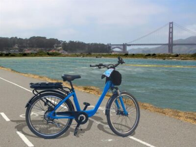
Point Reyes National Seashore Self Guided Driving Audio Tour
Book on Viator →Operated by Adventures with Action · Bookable on Viator
Point Reyes National Seashore can feel big. The key is making sense of it fast, and this self-guided driving audio tour does that with location-triggered narration and a simple route from Bear Valley toward the Point Reyes Lighthouse. I like that the audio is hands-free once it starts, so you can focus on parking, walking, and spotting wildlife. I also like how the stories mix dramatic coast scenes with real details—shipwreck rescue history, radio lore, and why elephant seals and sea lions bounced back. One caution: if you assume it’s staffed at the visitor center, you can waste time figuring out where to start.
This is built for a drive-only day that still includes walking. The route runs over 21 miles and takes about 2 to 3 hours, with about 53 audio stories, plus a few optional detours if you want to stretch your legs. At $16.99 per group (up to 4 people), it’s a strong value when you’re splitting the cost inside a car.
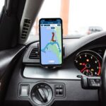
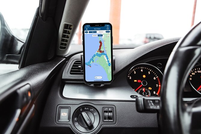
The tour also comes with real practical tech needs. You’ll download the app and the offline content ahead of time on strong cellular or Wi‑Fi, then it works without signal while you’re out there. If you get the start timing wrong or pass the same points in reverse, the GPS audio can feel a little out of sync.
In This Review
- Key highlights you’ll feel immediately
- How the GPS audio tour really works on this route
- Start at Bear Valley, finish at the Lighthouse Visitor Center
- Tomales Point detour for dramatic beach air
- Drakes Estero: marsh views plus a real trail choice
- Cypress Tree Tunnel and the KPH Radio station story
- Point Reyes Beach and Drakes Beach: sand miles and sea timing
- Chimney Rock trailhead detour: views with added effort
- Historic Point Reyes lifeboat station: 1878 rescue work
- Elephant seal and sea lion overlooks: what to look for
- South Beach overlook and the lighthouse parking reality
- Leaning Tree: the small stop that often becomes your best photo
- Price and value: why $16.99 per group can make sense
- My bottom line: who this tour fits best
- Should you book this Point Reyes self-guided audio drive?
- FAQ
- How much does the Point Reyes self-guided driving audio tour cost?
- How long does the tour take?
- Where does the tour start and where does it end?
- Does it work without cell service?
- Is the tour hands-free once it starts?
- Do I need a park pass?
- Can I use the audio through my car stereo?
- What if I want to walk at Drakes Estero or Chimney Rock?
- Is this tour staff-led?
- Can I cancel for a refund?
Key highlights you’ll feel immediately
- GPS-triggered audio that plays automatically as you drive past each stop.
- Tomales Point and the Point Reyes Lighthouse as the two big “money views” on this route.
- Optional walking choices like the 2.5-mile Drakes Estero trail and the Chimney Rock detour.
- Wildlife overlooks with viewing tips, including how to tell sea lions from seals.
- Offline maps and offline audio, so no phone signal needed mid-drive.
- One price per group (up to 4), which usually beats buying individual guided seats.
How the GPS audio tour really works on this route
This is a self-guided driving tour, not a meet-and-greet. When you arrive at the starting road, you open the Action Tour Guide app, enter the password you received by email/text, and then drive along the route. The audio stories trigger by GPS/location, so you’re not tapping menus every few minutes.
That matters because Point Reyes is a place where your best moments are on the roadside: a foggy pull-off, a trailhead sign, an overlook with seals hauled out, or a stretch of sand that looks endless. If the audio is constantly asking you to stop and interact with the phone, you miss the view. Here, it’s meant to play on its own, and you only “take over” when you park.
For sound, you have options. You can connect your phone to the car stereo with Bluetooth, USB, or AUX, which helps a lot if you want clear narration while driving. If you’ll park and walk, headphones can help so the audio stays steady even with wind. And yes—the tour is compatible with Apple CarPlay (Android Auto support is listed as coming soon).
The other practical rule: stick to the tour route and a safe speed. Since the audio is location-based, drifting off-route can make you miss the next story cue, or start it later than you expect.
You can also read our reviews of more guided tours in San Francisco


Start at Bear Valley, finish at the Lighthouse Visitor Center
Your start point is 1 Bear Valley Visitor Center Access Road in Point Reyes Station. You shouldn’t look for a guide or a desk. This tour doesn’t depend on park staff knowing your plan. You’ll drive past the start area, and the first audio should begin as you approach the story point.
The end point is Lighthouse Visitor Center, 27000 Sir Francis Drake Blvd, Inverness. That’s a nice design choice for a coastal loop day: you progress toward the classic finale instead of trying to backtrack to the start area.
One more logistics tip I learned the hard way on drives like this: plan your parking mindset early. The lighthouse area gets congested, especially on weekends, and the tour’s final stretch involves a major viewpoint payoff—so you don’t want to arrive already stressed about parking.
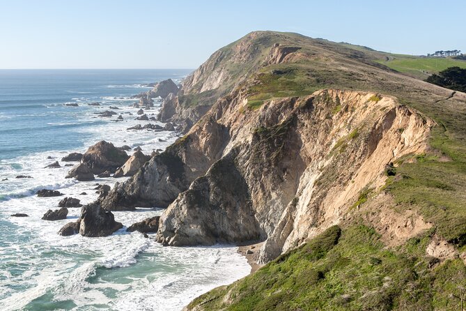
Tomales Point detour for dramatic beach air
Tomales Point is one of the most tempting offshoots on the peninsula. The tour gives you an option here: a remote, windswept stretch of beach that’s popular for a reason—weather creates drama, and the views don’t hold back.
You’ll see the story at the main route, but the detour adds time. The round trip detour is about 45 minutes, and you’ll want additional time to walk around and take photos. The walking isn’t described as a specific hike in this tour segment, so treat it as a “get your legs moving” stop: short paths, lookouts, and time to linger.
My practical take: if the wind is strong, dress for it. Coastal Point Reyes gusts can make your time feel shorter than planned because you’re fighting the cold. If it’s calm, this is where the coast starts to feel myth-like—wide horizons, changing light, and that constant ocean edge.
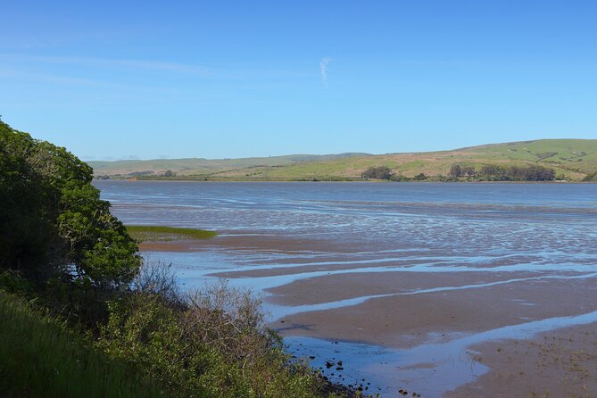
Drakes Estero: marsh views plus a real trail choice
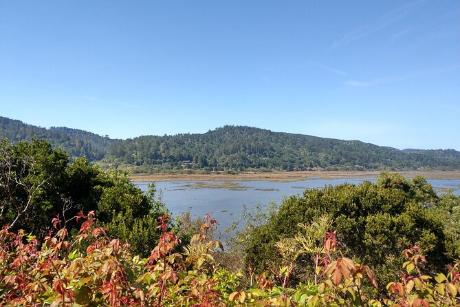
Next up is Drakes Estero, where “estero” just means marshy inlet. This stop is great because it mixes an easy scenic moment with an optional hike.
You get a chance to walk a 2.5-mile round-trip trail through the estero. The tour notes that you’ll cross coastal grasslands and reach a scenic footbridge over the bay. There’s also a clear turn decision: at the trailhead, you can leave the car for the hike, or keep driving if you’d rather save your energy for later viewpoints.
Why this is a smart inclusion: marsh areas are easy to overlook from a parking lot, but a short trail turns it into a different experience. You’re not just driving by; you’re moving through the habitat and getting a sense of how protected inlets shape the coastline.
A drawback to plan for: if you’re not into walking, you might still want to stop briefly for the view. But if you do hike, wear shoes that handle uneven ground and keep an eye on footing near water and grass.
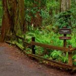
Cypress Tree Tunnel and the KPH Radio station story

Cypress Tree Tunnel is the kind of scene you want to slow down for. Rows of cypress trees form a tunnel effect, and the story connects it to an early 1900s coastal radio network.
The narration explains how Morse code radio stations were placed along the coast so ships at sea could communicate more efficiently. In 1929, RCA built a station here at Point Reyes, and they reportedly planted the cypress rows specifically to do justice to the landscape around the site.
Even if radio history isn’t your main interest, this stop works because it reframes what you’re seeing. The trees aren’t just pretty. They’re part of a human attempt to solve a communications problem while still shaping the site.
Practical note: this is a short stop, but it’s a good place to step out for photos and then get back in the car quickly if you’re on a tight schedule.
You can also read our reviews of more tours and experiences in San Francisco


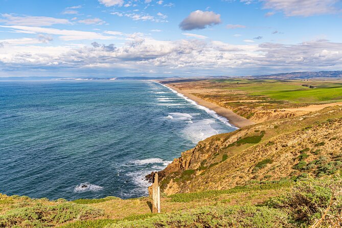
Point Reyes Beach and Drakes Beach: sand miles and sea timing
The tour splits the big ocean-beach experience into two story stops, and that’s helpful. It’s easier to compare than if everything was crammed into one vague “beach segment.”
At Point Reyes Beach, you’re told it’s 11 miles of sand with strong ocean views. The narration also calls out that people often report gray whale sightings in winter and spring, which is worth remembering if you visit during those seasons.
Then you reach Drakes Beach, which faces Drakes Bay. That single detail changes what you feel on the ground: the tour explains that winds are generally less intense and waves can be less harsh here than on the open ocean-facing side. There are also white sandstone cliffs in the background.
My advice: if you want a calmer beach experience, aim your time at Drakes Beach. If you want maximum ocean drama, Point Reyes Beach is the better match. Either way, bring layers and give yourself time to just watch—this area can look flat from a distance, but up close you’ll notice constant motion in the waterline and moving clouds.
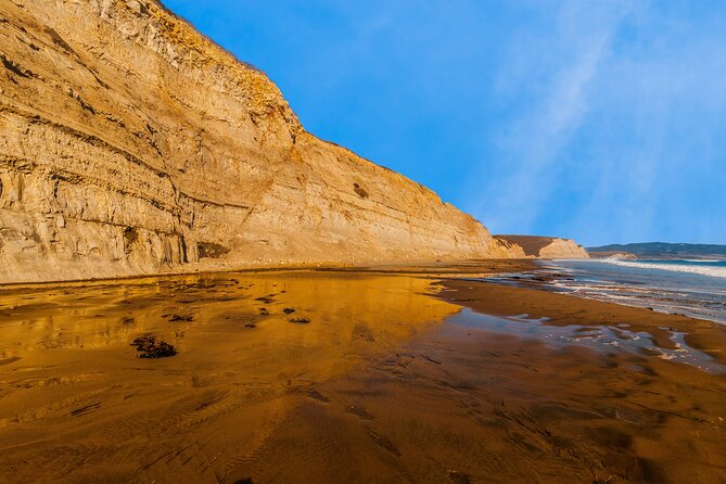
Chimney Rock trailhead detour: views with added effort
The next “turn left” moment is for a detour tied to a few goals at once. You’ll take that fork to reach an overlook, a lifesaving station, and an option to hike out toward Chimney Rock for ocean views. The stop is positioned so you can choose how ambitious you want to be.
This segment matters because it turns your drive into a layered visit. You get the overlook portion even if you don’t feel like hiking far, and if you do, Chimney Rock is set up as the “payoff” view.
Planning consideration: detours can quietly eat time. The tour doesn’t list a specific hike length here, so you’ll want to budget extra minutes for parking, route-finding on foot, and turning around at a pace you’re comfortable with.
Historic Point Reyes lifeboat station: 1878 rescue work
The tour then slows down into story mode at the Historic Point Reyes Lifeboat Station, described as the first life-saving station at Point Reyes. It began operations in 1878, and the narration includes the language of the work: the station leader was called the “keeper,” and the staff were called “surfmen.”
This is one of those stops where the coast makes sense as more than scenery. Staff would patrol beaches for wrecks and listen for voices through fog, and the narration states the system worked: the first station saved people from 14 major shipwrecks over 37 years.
Why I like this kind of stop on an audio tour: it connects what you see to why people invested in it. Fog, waves, and hidden shorelines are not just pretty. They’re dangerous, and the history helps you read the coastline like a map.
There’s no requirement to walk far here. Treat it as a “listen longer than you think” moment, then move on once you’ve got the story picture in your head.
Elephant seal and sea lion overlooks: what to look for
This is where Point Reyes turns into wildlife viewing done at road-accessible stops.
First comes the Elephant Seal Overlook. The narration explains how northern elephant seals were hunted for oil by European settlers, and by 1892 the number dropped to about 75 seals across North America. It also notes federal protection in the 1920s and a slow rebound: the first breeding pair returned to Point Reyes in 1981, and today the population is given as around 200,000 along the Pacific coast.
Next is the Sea Lion Overlook, and the tour gives practical identification tips. It notes there are 54 steps down to the coastal view, and it explains how to tell seals from sea lions:
- Sea lions show ear flaps
- They have folded-in back flippers
- Sea lions can shuffle upright on land using those back flippers
It also gives key timing and behavior: breeding season is between May and August, males are listed around 8 feet and females around 6 feet, and the narration describes fasting, territory defense, and court-call behavior.
Here’s my take for your visit: don’t rush this section. Even if you only plan to glance, give yourself a full minute or two. Animals often shift positions on their own schedule, and the difference between a quick look and a real look is huge.
Also, because the sea lion viewpoint includes stairs, decide in advance if you want that effort today. If you’d rather save energy, you can still enjoy the elephant seal overlook nearby without going as far down.
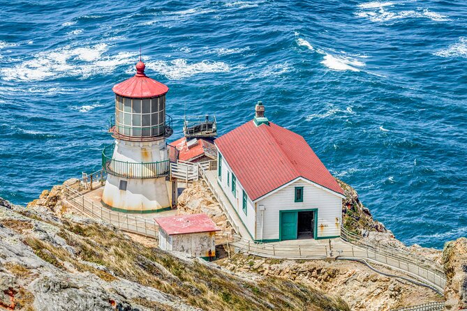
South Beach overlook and the lighthouse parking reality
As you approach the lighthouse, the tour leads you to the South Beach Overlook and the Point Reyes Lighthouse area.
A practical detail matters here: this is the only parking lot for the lighthouse, and the tour recommends parking once you get there. If it’s full, you can street park, but it says street parking near the lighthouse gets congested, especially on weekends.
So plan your finale like a commuter: arrive with patience and expect slow-moving crowds. If you care most about the view, you’ll be happier if you don’t treat the area as a quick photo stop.
Once parked, the lighthouse area is the tour’s obvious climax. You’ll combine your earlier story context—lifesaving history, coastline danger, radio-era communication—with the iconic structure at the tip of the route. That “why it’s here” feeling is what makes this last segment land.
Leaning Tree: the small stop that often becomes your best photo
Before you wrap up, the tour includes Leaning Tree. It’s another cypress tunnel-style stop, described as a tunnel where there are fewer trees than the earlier cypress tunnel you saw near the radio station. Cross under the leaning-tree path bend, and you’ll see a cypress that leans over the path but, as commonly described, seems like it never falls.
This is a short stop, but it’s a good wind-down before you head to the lighthouse visitor end point. It also gives you a different kind of photo: not just coastline and architecture, but a single tree and its strange shape.
Price and value: why $16.99 per group can make sense
At $16.99 per group (up to 4), the tour’s biggest value is simple: you pay per car, not per person. That’s ideal for small families, couples with a guest, or a couple of friends sharing rides.
You’re also buying something harder to price: focused time. Instead of joining a bus schedule, you can pause for snacks and photos, and you can start anytime during your visit hours. That flexibility matters at Point Reyes, where weather changes fast and parking patterns change hour to hour.
One more value angle: the audio is designed to work offline, and it doesn’t rely on you constantly checking a map. For cell-signal gaps, that’s not a minor perk—it’s the difference between enjoying your day and constantly fighting your phone.
My bottom line: who this tour fits best
This is a great match if you want:
- A self-guided day with stories while you drive
- A route that ties together wildlife overlooks and key coastline viewpoints
- Optional walks like Drakes Estero and the Chimney Rock detour, depending on your energy
It’s less ideal if:
- You dislike app setup and want a human presence at every step
- You expect the narration to match perfectly if you do a lot of back-and-forth, since GPS-driven audio can behave oddly when you revisit points in reverse
- You have trouble with smartphone navigation or prefer printed directions only (though the tour includes support if you get stuck)
Should you book this Point Reyes self-guided audio drive?
I’d book it if you’re planning a day at Point Reyes and you want the coast plus the stories, without paying for a traditional guide. The price is reasonable for a car group, and the offline GPS setup is built for exactly this kind of park day.
I’d hesitate only if you know you’ll struggle with downloading an app first and following GPS audio cues. If that worries you, set yourself up for success: download on strong Wi‑Fi before you leave, then test the audio volume in your car stereo before you roll into the main drive.
If you’re comfortable with a phone-based self-guided experience, this route gives you a well-paced way to hit the highlights—Tomales Point, Drakes Estero, the cypress tunnels, lifeboat history, elephant seals, sea lions, and the lighthouse finale—without wasting time figuring out what to do next.
FAQ
How much does the Point Reyes self-guided driving audio tour cost?
It costs $16.99 per group, for up to 4 people.
How long does the tour take?
Plan for about 2 to 3 hours. The route is over 21 miles long.
Where does the tour start and where does it end?
It starts at 1 Bear Valley Visitor Center Access Road, Point Reyes Station, CA 94956. It ends at the Lighthouse Visitor Center, 27000 Sir Francis Drake Blvd, Inverness, CA 94937.
Does it work without cell service?
Yes. You need to download the tour while you have strong Wi‑Fi/cellular, then it works offline afterward. It also includes offline maps.
Is the tour hands-free once it starts?
Yes. Audio stories play automatically based on your location, and the tour is designed to be hands-free while you drive and park.
Do I need a park pass?
Park passes are not included. The tour notes that listed stop admissions are free, but you should still plan for any required park entry.
Can I use the audio through my car stereo?
Yes. You can connect your phone to your car’s stereo using Bluetooth, USB, or AUX. Apple CarPlay is listed as compatible.
What if I want to walk at Drakes Estero or Chimney Rock?
At Drakes Estero, you can turn left at the trailhead for a 2.5-mile round-trip walk. For Chimney Rock and the related lifesaving station overlook, the tour directs you to turn left at the fork.
Is this tour staff-led?
No. It’s self-guided, and no one meets you at the start. Your group only participates.
Can I cancel for a refund?
Yes. Free cancellation is available up to 24 hours in advance for a full refund. If you cancel less than 24 hours before the start time, it’s not refunded.