REVIEW · SAN FRANCISCO
San Francisco Urban Hike: Castro and Twin Peaks
Book on Viator →Operated by Urban Hiker SF · Bookable on Viator
Every SF block feels different fast. This 3-hour, moderate hike mixes neighborhood climbs with big overlooks, plus a ride down the Seward Street Slides. You start at the historic Castro Theatre, then work your way up through quiet parks, eucalyptus paths, and resident-only trails toward Twin Peaks.
Two things I really like: you get multiple view stops (Twin Peaks and Tank Hill) and you also get the city’s playful side with the slide-through-a-concrete-curve moment. One drawback to plan for: it is hilly and stair-heavy, so you’ll want decent shoes and a steady pace—this one is not for minimal walking days.
In This Review
- Key highlights at a glance
- Why this hike feels more like an insider route than sightseeing
- Start at Castro Theatre: a handy meeting point and a great first vibe
- Kite Hill Open Space: views first, then the satisfaction of finding it
- Seward Street Slides: the funny detour that turns into the day’s memory
- Sutro Tower eucalyptus forest: when the city quiets down
- Twin Peaks summit: the big view you work for
- Tank Hill and Golden Gate views: another overlook, less tourist pressure
- The 211-step Pemberton Place stairway: where the walk turns scenic and steep
- How long it takes and what moderate really means on SF hills
- What you’ll learn: city facts that make the streets make sense
- Included value: a professional guide and practical access to key stops
- Practical tips so you feel comfortable (and not stressed)
- Who this hike suits best
- Should you book the Castro and Twin Peaks urban hike?
- FAQ
- How long is the San Francisco Urban Hike: Castro and Twin Peaks?
- Where does the hike start and end?
- What fitness level do I need?
- Is it suitable for children?
- What should I wear and bring?
- Does it run in the rain?
Key highlights at a glance

- Castro Theatre start/finish: you begin and end right by a classic movie palace.
- Kite Hill Open Space: a hilltop that’s visible, but easy to miss on your first try.
- Seward Street Slides: curved cement slides you can actually ride (cardboard helps).
- Behind Sutro Tower eucalyptus forest: a sudden shift from streets to a nature-feeling path.
- Twin Peaks summit views: sweeping sights across the waterfront and the East Bay Hills.
- Tank Hill + Pemberton Place steps: another viewpoint, then a long stair descent through homes and gardens.
Why this hike feels more like an insider route than sightseeing
San Francisco hills can make even a short walk feel like training. That’s exactly why I like this route: you don’t just hit postcard overlooks—you also get the in-between trails and stairways that most visitors never bother with.
The other big reason it works is pacing. You’re moving for about 3 hours, with time to pause at key points for photos and city views, without turning the day into a slog. The guide keeps the group together while you switch settings: theater district energy, park green space, eucalyptus shade, then panoramic overlooks.
And you’ll see why the guide matters. On prior tours, guides like Kevin, Alex, and Val were praised for being friendly and SF-native, which changes the whole feel of the walk. You’re not just collecting angles—you’re picking up street-level context as you go.
You can also read our reviews of more hiking tours in San Francisco


Start at Castro Theatre: a handy meeting point and a great first vibe
The hike begins (and ends) at 429 Castro St, at the Castro Theatre. It’s not just convenient; it gives you a clear visual anchor in a neighborhood that can feel busy and confusing if you’re navigating alone.
You’ll also start with a quick stop that sets the tone: a short look at the theatre’s history, then you’re out and climbing. In practical terms, that opener helps you settle into walking mode before the hills intensify.
One small planning tip: build in time to find the exact meeting area. “Historic and iconic” means it’s easy to be nearby but not actually at the right spot.
Kite Hill Open Space: views first, then the satisfaction of finding it
After Castro, the route heads up toward Kite Hill Open Space. This is a city hill you can see, but it’s tricky to locate on your own. That’s part of the fun: it feels like you’re learning the city’s hidden logic as you climb.
Kite Hill is also a smart early payoff. You pause near the top for city views and photo ops, which makes the first stretch feel worth it rather than purely effort. This stop is also the kind of place where the “neighborhood residents” vibe comes through—you’re not stuck in a tourist-only viewing pen.
The only drawback here is energy management. Since you’re just warming up, don’t rush the hill. Save your legs for later stairs, especially once you’re moving toward the slide area and the Twin Peaks climb.
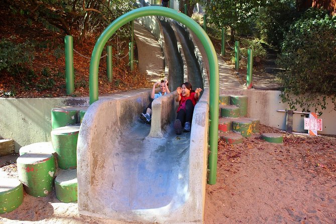
Seward Street Slides: the funny detour that turns into the day’s memory
Then the route swings to Seward Street Slides, a playful stop in the middle of a park. This is one of those SF moments that doesn’t sound real until you’re standing there, watching people line up to slide down curved concrete.
What makes it special isn’t just the fun. It’s that the slides are such a local, low-tech tradition—people bring cardboard and take turns. The route basically gives you a break from heavy uphill effort while still keeping momentum.
If you want to maximize this stop:
- Bring a layer you’re comfortable getting slightly dusty in.
- Have your cardboard ready before you start lining up, since it’s part of the ritual.
Wear shoes with solid grip. Slides are fun, but you still have to walk back up and around the slide area safely.
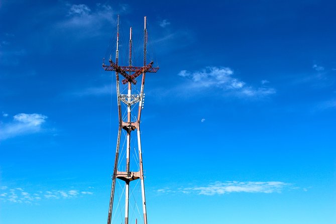
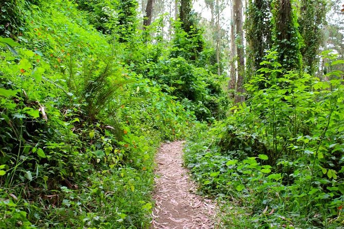
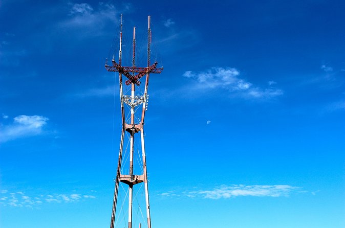
Sutro Tower eucalyptus forest: when the city quiets down
From the slides, you move toward Sutro Tower, then into a eucalyptus forest behind it. This is the part of the hike that feels like a switch flips: streets fade, shade appears, and the path starts to feel more like a trail than an urban walk.
This stop is also a good reminder of what you’re getting on this tour: not just famous viewpoints, but off-the-beaten-path spaces that are hard to find without a guide. The route follows an unmarked trail style, more like a path worn by residents over time.
Drawback to consider: unmarked trails mean you’ll want to stay alert. The guide keeps things moving, but you should still expect uneven ground and the occasional step-up/down feeling as you walk through that forest area.


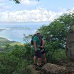
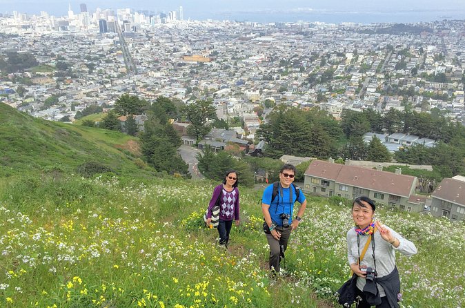
Twin Peaks summit: the big view you work for
Next up is the climb to Twin Peaks. This is where the effort pays off in a major way. You reach the summit and get panoramic views across the San Francisco waterfront and toward the East Bay Hills.
Twin Peaks is the kind of place that changes your sense of scale. From street level, SF can feel like a steep maze. From the summit, you see how the neighborhoods stack and how the coastline and hills relate.
Time at the top is built in so you can breathe and get photos without feeling rushed. Still, don’t assume it’ll be a casual stroll. You’re hiking uphill and then lingering at altitude-style viewpoints, so pace yourself through the approach.
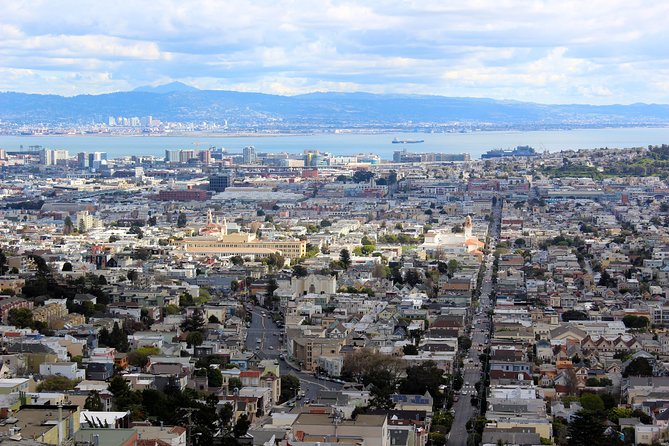
Tank Hill and Golden Gate views: another overlook, less tourist pressure
After Twin Peaks, the route heads to Tank Hill. It’s another popular neighborhood park viewpoint, and it gives you a different angle—especially toward the ocean, the bay, the Golden Gate Bridge, and downtown.
The summit sits at about 650 feet, and the payoff is northern-side views as well as the kind of wide horizon you can’t get from most city streets. The best part is that you’re seeing how SF layers: hills, water, and bridge geometry all at once.
You’ll also notice why this stop is often loved by locals. It’s not only about the view; it’s also part of everyday park life, including dog walking. That gives the stop a more lived-in feel than a simple lookout point.
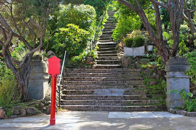
The 211-step Pemberton Place stairway: where the walk turns scenic and steep
The last major effort is the descent via Pemberton Place Stairway, which winds through neighborhood houses and private gardens. The tour describes 211 steps, so plan your rhythm before you start.
This part matters because it changes how you experience the city. You’re not facing out at the skyline; you’re moving through a residential world with curves, yards, and quiet charm. It’s a great way to end the climb-focused day with something slower and more scenic.
Potential drawback: stairs are hard on tired legs. If you know you’re sensitive to downhill impact, take shorter steps, keep a steady pace, and use the guide’s cues for the flow of the group.
How long it takes and what moderate really means on SF hills
The walk runs about 3 hours and covers roughly 5 miles (8 km). That might sound reasonable until you factor in San Francisco’s vertical reality. This is labeled as moderate, but that moderation is still very much about hills and stairways.
A maximum group size of 15 travelers keeps it manageable. With a small group, you’re less likely to feel lost or stuck behind slow movement, and the guide can keep everyone together on the unmarked sections.
If you’re choosing this tour, the best rule is simple: if you’re comfortable with uphill walking and stairs for a sustained period, you’ll be happy. If not, you’ll probably feel it.
What you’ll learn: city facts that make the streets make sense
Part of the experience is the guide’s commentary. You’ll get facts about San Francisco as you go, tied to the spots you’re passing—like why certain places matter, how neighborhoods connect, and what you’re seeing from the hilltops.
The reviews highlight how guides who are clearly rooted in the city—such as Dawn, Max, and Alex—add warmth and context. You don’t just hear place names; you learn what to notice when you look out from Twin Peaks or when you step into the eucalyptus shade.
Even if you already know the basics, this kind of walking “interpretation” helps the city feel less random.
Included value: a professional guide and practical access to key stops
This tour includes a professional guide, and most admission stops are marked as free, with Tank Hill included. That’s good value because you’re paying for the guidance and the route—things you can’t easily replicate on your own without research.
You also get a mobile ticket, which is handy when you’re meeting at a busy corner and trying to keep the day smooth. And since the tour starts and ends at the same spot, it’s easier to build a meal plan after.
No hotel pickup is included, so you’ll want to handle your own arrival. The meeting area is near public transportation, which helps if you don’t want to deal with driving and parking.
Practical tips so you feel comfortable (and not stressed)
This hike runs rain or shine. If it’s raining and you’d rather not attend, you can reschedule or request a refund. Also, the tour is described as requiring good weather, so keep an eye on conditions close to departure.
Bring:
- Comfortable shoes or hiking boots with good grip.
- Layers (SF weather changes fast).
- Water (recommended).
- Your phone for photos, but save battery for the view stops.
If you’re sensitive to steep grades, keep your pace slightly slower than you think you need. The surprise isn’t the first hill; it’s the way your legs feel after multiple climbs and a stair descent.
Who this hike suits best
This is a strong fit for adults or teens who like active days but don’t want an all-day trek. You’ll probably enjoy it most if you’re:
- Comfortable walking 5 miles with hills
- Interested in SF neighborhoods beyond the main attractions
- Interested in viewpoints that come with context, not just crowds
It’s not recommended for children 12 and younger, mainly because of the distance and intensity. Service animals are allowed, which is good to know for planning.
Should you book the Castro and Twin Peaks urban hike?
Book it if you want SF views with real walking—and you like the idea of mixing famous overlooks with practical, local-feeling stops like slides and eucalyptus paths. This route is ideal for a first or second trip to San Francisco when you want something more personal than a bus tour.
Skip it (or choose a lighter option) if your legs don’t handle stairs well, or if you prefer flat sightseeing. The scenery is worth the effort, but SF hills don’t negotiate.
FAQ
How long is the San Francisco Urban Hike: Castro and Twin Peaks?
The tour is about 3 hours.
Where does the hike start and end?
It starts at 429 Castro St, San Francisco, CA 94114, USA, and ends back at the same meeting point.
What fitness level do I need?
You should have a moderate physical fitness level, since the hike is described as having distance and intensity due to hills and stairs.
Is it suitable for children?
It is not recommended for children 12 years and younger.
What should I wear and bring?
Wear comfortable shoes or hiking boots and dress in layers. Bringing drinking water is recommended.
Does it run in the rain?
The tour runs rain or shine, and if it’s raining and you would prefer not to attend, you may reschedule or request a refund.